Table of Contents >> Show >> Hide
- What “real-time” boat and ship tracking really means
- How vessel tracking works behind the scenes
- Why people track boats and ships in real time
- How to track multiple boats and ships at once
- The role of MMSI, Class A, and Class B
- The biggest limitations people forget
- Best real-world uses for real-time ship and boat tracking
- Where real-time marine tracking is heading next
- Final thoughts
- Experiences related to tracking boats and ships in real time at the same time
If you have ever stared at a live vessel map and thought, “Wow, I am basically an air traffic controller for the ocean,” you are not alone. Real-time boat and ship tracking has gone from niche maritime tech to an everyday tool for sailors, logistics teams, coastal businesses, researchers, and curious people who simply want to know why a giant cargo ship is creeping toward a port like it forgot where the parking lot is.
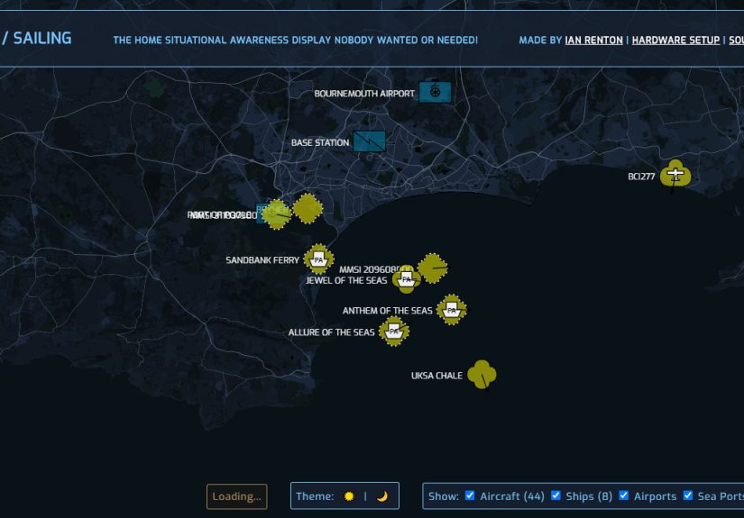
Today, tracking boats and ships in real time at the same time is easier than ever. You can follow a tug in a harbor, a ferry on a regular run, a fishing vessel offshore, and a massive container ship crossing toward a busy terminal without switching your brain into advanced naval-engineering mode. The secret sauce behind it is a mix of AIS data, GPS positioning, shore receivers, satellites, chart platforms, and a growing ecosystem of public and professional tools.
This matters for more than curiosity. Real-time ship tracking improves maritime safety, helps avoid collisions, supports search and rescue, sharpens weather awareness, informs ocean planning, and gives businesses a clearer picture of how vessels move through ports and waterways. In plain English, it helps people make better decisions before a ship arrives, before a storm hits, and before someone says, “Wait, where did the boat go?”
What “real-time” boat and ship tracking really means
In everyday use, real-time vessel tracking means seeing a boat or ship’s position, course, speed, and identifying details on a digital map as fresh data comes in. For commercial ships, that often includes the vessel name, MMSI, type, destination, and other voyage-related details. For smaller recreational vessels, the visible information depends on whether the boat carries AIS, how it is configured, and whether the tracking service has access to that signal.
The important detail is this: “real time” does not always mean “zero delay.” Some professional systems are close to live. Some public-facing tools may be delayed. Some datasets are historical by design. Some platforms blend terrestrial AIS with satellite inputs, while others only use land-based receivers. So if a boat appears late, disappears offshore, or pops up again later, the map is not necessarily broken. The ocean is just rude to easy assumptions.
Boats and ships are not the same tracking problem
Large commercial ships are usually easier to track because many are required to carry AIS equipment and transmit consistently. Smaller boats are a different story. A recreational vessel may have no AIS at all, a receive-only setup, or a transponder that is only helpful when it is powered, properly installed, and within useful coverage. That is why tracking boats and ships in real time at the same time requires a little flexibility. One map may show the cargo ship beautifully while your weekend center console acts like a celebrity dodging paparazzi.
How vessel tracking works behind the scenes
The backbone of modern marine tracking is AIS, or Automatic Identification System. AIS uses VHF radio to exchange vessel information automatically between ship and ship and between ship and shore. The data often includes a vessel’s identity, GPS position, speed over ground, course over ground, and sometimes destination or draft. AIS was built first and foremost as a navigation and collision-avoidance tool, which is why it remains so important even now that public tracking maps make it look almost casual.
AIS is tied closely to GPS. The vessel’s position is embedded in the data it transmits, and that information can then be shown on electronic charts, navigation displays, or web-based live maps. In practical use, the vessel transmits the data, shore stations receive it, and platforms organize it into something humans can understand without needing a PhD in maritime acronyms.
Terrestrial AIS vs. satellite AIS
There are two big ways to collect vessel signals. The first is terrestrial AIS, which relies on shore-based receivers. This works well near coasts, ports, harbors, and inland waterways. The second is satellite AIS, which extends visibility much farther offshore. If you are tracking ships near a busy port, land-based coverage may be excellent. If you are following a vessel across remote ocean space, satellite support becomes much more important.
This difference explains why a ship can look perfectly trackable near Los Angeles, Miami, or Seattle and then become harder to follow far from shore. AIS is a VHF system, and VHF coverage is fundamentally limited by line of sight. That means the sea is large, the horizon is stubborn, and not every vessel can be watched equally from every place.
Why some vessels do not appear on the map
There are several reasons a boat or ship may not show up. The vessel may not carry AIS. It may be outside receiver range. Its equipment may be off, misconfigured, or transmitting incomplete data. Some public datasets intentionally exclude certain federal, military, or law-enforcement vessels. And in dense traffic areas, data congestion and imperfect reception can create gaps.
So yes, live vessel tracking is powerful. No, it is not magic. It is best thought of as a smart, constantly updating maritime picture rather than an omniscient ocean crystal ball.
Why people track boats and ships in real time
1. Safety and collision awareness
The most important use of AIS-based tracking is safety. On the water, knowing another vessel’s position, direction, and speed can help mariners evaluate risk and avoid bad decisions. A moving symbol on a chart is not just interesting; it can be the difference between an orderly passing situation and a story that starts with, “Well, nobody saw the tug until it was too late.”
2. Port arrivals and logistics
Shippers, importers, port staff, trucking coordinators, warehouse teams, and even customers use vessel tracking to estimate arrivals and plan around delays. Watching a container ship’s approach can help people time labor, yard operations, unloading, transfers, and inland transport. Real-time ship tracking has become a practical business tool, not just a maritime novelty.
3. Weather and route awareness
Vessel tracking is also useful in bad weather. When ship positions are combined with real-time weather data, forecasters and operators can better understand avoidance behavior, hazardous conditions, and route changes. That is especially valuable in areas where storms, heavy seas, or traffic density raise the stakes.
4. Fisheries, compliance, and marine research
Tracking data supports fisheries monitoring, marine mammal protection, ocean planning, and traffic analysis. Researchers and public-interest organizations also use vessel identity and activity information to study fishing operations, port visits, risk patterns, and behavior over time. This is one reason marine tracking has become more sophisticated than a simple “dot on a map” experience.
How to track multiple boats and ships at once
If your goal is to track boats and ships in real time at the same time, the best approach is not just opening one tab and hoping for genius. It helps to think in layers.
Start with the vessel type
A ferry, cruise ship, tanker, tug, and sailboat may all behave differently on a tracking platform. Commercial vessels often transmit more consistently. Recreational boats are hit or miss. Fishing vessels may appear in specialized tools with added identity or activity analysis. Knowing what kind of vessel you are looking for saves time and keeps you from blaming the internet for problems that are really hardware, coverage, or policy issues.
Use the right platform for the job
General live ship maps are great for watching commercial traffic and port approaches. Government-backed data portals are better for analysis, downloads, and historical traffic patterns. Specialized platforms can help with fishing vessel identity, risk signals, or regional monitoring. If you need operational awareness, you may want a professional tool. If you just want to know whether the ferry is actually moving or merely thinking about moving, a public-facing map may be enough.
Create a practical workflow
For everyday users, a simple workflow works best:
- Search by vessel name, MMSI, or IMO number when available.
- Save or favorite the vessels you care about.
- Check speed, heading, and last reported position before drawing conclusions.
- Compare vessel movement with port congestion, weather, and route context.
- Expect smaller boats to be less consistently visible than large ships.
That sounds obvious, but it prevents the classic mistake of assuming a vessel is lost when it is merely beyond shore coverage, temporarily delayed, or behaving like a boat instead of a train.
The role of MMSI, Class A, and Class B
MMSI stands for Maritime Mobile Service Identity. It is a unique nine-digit number used to identify a vessel or radio station in maritime communications systems, including AIS. Think of it as the vessel’s digital calling card. If you are searching for a specific boat or ship, the MMSI can be far more reliable than a vessel name, especially when several boats have suspiciously similar names like Sea Breeze, Sea Breeze II, and Still Sea Breeze Somehow.
You will also hear about Class A and Class B AIS. In broad terms, Class A is associated with larger, regulated commercial operations and more robust mandatory carriage requirements. Class B is commonly used by smaller vessels and voluntary users. For recreational boaters, Class B can dramatically improve visibility to other vessels and compatible tracking systems, but it still depends on proper installation, accurate programming, and real-world coverage.
The biggest limitations people forget
Coverage gaps are normal
Land-based AIS does not cover the whole world. Nearshore reception is often solid, but far offshore coverage can fall away without satellite support. Even public U.S. planning data acknowledges that land-based AIS may underrepresent areas beyond roughly 40 to 50 miles from the coast, foreign waters, and some remote regions.
Live maps are not a substitute for seamanship
This is a huge one. Vessel tracking is helpful, but it does not replace radar, visual lookout, chart awareness, radio communication, or navigation rules. A smart mariner treats AIS as one tool among several, not a cheat code that cancels common sense.
Data quality depends on people and equipment
AIS can contain outdated, missing, or poorly entered information. Destination fields may be messy. Equipment can be misconfigured. GPS issues can affect position quality. Some records are filtered, delayed, or incomplete depending on the platform. In other words, the data is useful, but it still has to survive contact with reality.
Best real-world uses for real-time ship and boat tracking
For business users, vessel tracking supports estimated arrival planning, supply chain timing, terminal scheduling, and monitoring of high-value shipments. For boaters, it improves situational awareness and helps identify commercial traffic around inlets, channels, and busy approaches. For coastal communities, it helps make sense of harbor activity, cruise schedules, and seasonal shipping patterns.
For researchers and planners, AIS-based vessel traffic data can reveal how ships actually move through real spaces over time. That matters for environmental assessments, protected species management, route design, infrastructure planning, and risk analysis. Once you stop thinking of vessel tracking as a novelty map and start thinking of it as movement intelligence, the value becomes much clearer.
Where real-time marine tracking is heading next
The future of marine tracking is not just “more dots on a map.” It is better integration. We are already seeing vessel data combined with weather feeds, analytics, compliance information, historical patterns, geofencing, replay tools, and APIs. Specialized tools now help users analyze vessel identity, group fleets, review past movement, and assess operational risk.
For everyday users, this means marine tracking will likely keep getting easier to search, easier to customize, and more useful across phones, laptops, and onboard systems. For industry users, it means more automation, stronger data pipelines, and better decision support. The ocean will still be big, messy, and dramatic, but the data layer above it is getting sharper every year.
Final thoughts
Tracking boats and ships in real time at the same time sounds like a mouthful, but the idea is straightforward: use AIS-driven tools, understand the difference between boats and commercial ships, respect the limits of coverage, and choose the right platform for what you actually need. If you do that, you can monitor harbor traffic, follow vessel arrivals, improve maritime awareness, and make smarter decisions without drowning in jargon.
The best part is that real-time vessel tracking now serves both professionals and regular users. You can be a port planner, a recreational boater, a supply chain analyst, a weather nerd, or simply someone who enjoys watching floating logistics unfold in slow motion. Either way, modern marine tracking turns the ocean from a mystery into a moving, searchable story.
Experiences related to tracking boats and ships in real time at the same time
One of the most interesting things about tracking boats and ships in real time is how quickly it stops feeling abstract. The first time you watch a container ship inch toward a port while a pilot boat darts out to meet it, the map suddenly feels alive. It is not just software anymore. It is choreography. Big ships move with patient, almost stubborn momentum, while smaller support vessels zip around like they had three espressos and a deadline.
People who use these tools regularly often describe the experience as part practical, part addictive. A logistics manager may open a vessel map to confirm an arrival window and end up watching traffic patterns for twenty minutes because the port looks like organized chaos. A recreational boater may check nearby commercial traffic before leaving the marina and discover that a tug-and-barge combination is moving through the channel exactly when they planned to head out. That small moment of awareness can change timing, route choice, and overall safety.
There is also a surprisingly human side to marine tracking. Families sometimes follow ferries, cruise ships, or delivery vessels the way people track flights. Charter businesses watch weather and nearby traffic together. Harbor communities keep an eye on seasonal movements and recognize familiar traffic patterns. In fishing and enforcement contexts, the experience becomes more serious, with users relying on vessel histories, port visits, and movement clues to support decisions that affect access, inspections, and compliance.
For researchers and ocean planners, the experience is different again. Instead of watching one vessel, they often examine patterns over days, months, or years. A single point on a map may not mean much, but thousands of them can reveal routes, congestion points, sensitive habitat overlap, and behavior changes during storms or regulations. The “real-time” layer gives immediacy, while the historical layer adds meaning.
Of course, anyone who spends enough time with live vessel maps also learns humility. Sometimes the boat you want is not visible. Sometimes the ship updates slowly. Sometimes a destination field looks like someone typed it while bouncing through six-foot chop. Sometimes the vessel appears to stop, only to reveal later that the tracker refreshed late or coverage was weak. These moments are frustrating, but they are also a reminder that marine tracking is a tool shaped by antennas, radios, satellites, geography, weather, and human input.
Still, that mix of usefulness and unpredictability is exactly what makes the experience compelling. You are not just looking at a static record. You are watching movement, decision-making, timing, and geography all play out together. Real-time tracking gives the public a window into a world that used to be largely invisible unless you were standing on a pier with binoculars. Now the pier fits in your browser, your phone, or your bridge display.
And maybe that is the most memorable part of the experience: you start by trying to answer a simple question like “Where is that ship?” and end up understanding much more. You notice how weather shifts traffic, how ports pulse with activity, how smaller boats vanish from coverage faster than larger ships, and how maritime systems depend on both technology and judgment. It is practical, fascinating, occasionally imperfect, and surprisingly hard to stop watching once you realize the whole ocean is quietly broadcasting its traffic report.